You are here

Maps - Global

Primary tabs

This working group is focused on discussions about maps.

The mission of this working group is to focus on discussions about maps.

Members

Hank Rappaport Kathy Gilbeaux mdmcdonald typackett

Email address for group

maps-global@m.resiliencesystem.org

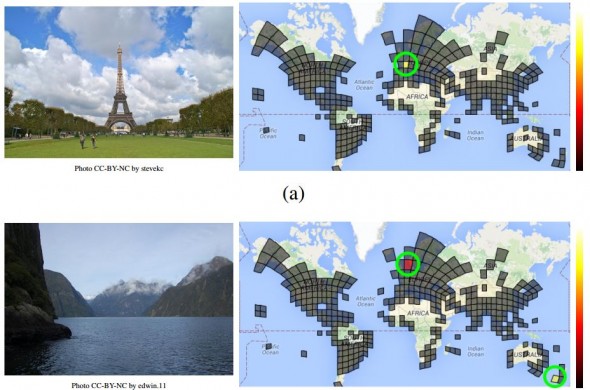
Google Unveils Neural Network with “Superhuman” Ability to Determine the Location of Almost Any Image


Guessing the location of a randomly chosen Street View image is hard, even for well-traveled humans. But Google’s latest artificial-intelligence machine manages it with relative ease.

CLICK HERE - PlaNet - Photo Geolocation with Convolutional Neural Networks

CLICK HERE - GeoGuessr

technologyreview.com - by Emerging Technology from the arXiv - February 24, 2016

Here’s a tricky task. Pick a photograph from the Web at random. Now try to work out where it was taken using only the image itself. . . .

. . . Tobias Weyand, a computer vision specialist at Google, and a couple of pals . . . have trained a deep-learning machine to work out the location of almost any photo using only the pixels it contains.

Their new machine significantly outperforms humans and can even use a clever trick to determine the location of indoor images and pictures of specific things such as pets, food, and so on that have no location cues.

(READ COMPLETE ARTICLE)


Country / Region Tags: 
General Topic Tags: 
Problem, Solution, SitRep, or ?: 

Zika - List of Map Resources

An expanding list of map resources related to Zika virus . . .

Map - PAHO | WHO - Zika
http://ais.paho.org/phip/viz/ed_zika_countrymap.asp

HealthMap - 2016 Zika Outbreak
http://www.healthmap.org/zika/#timeline

CDC - All Countries and Territories with Active Zika Virus Transmission
http://www.cdc.gov/zika/geo/active-countries.html

FRONTLINE - The Spread of Zika
http://apps.frontline.org/zika/

2016 Zika Linked Microcephaly / Fetal Brain Disruption Sequence
https://www.google.com/maps/d/viewer?mid=1RcVTrkYW6hax_iITjKUkEcBCVeI

Zika Virus - Zika Virus in United States, Territories, and Canada
https://www.google.com/maps/d/embed?mid=zv94AJqgUct4.kT4qLMXp3SLU&hl=en
OR
https://www.google.com/maps/d/viewer?hl=en&hl=en&authuser=0&authuser=0&mid=zv94AJqgUct4.kT4qLMXp3SLU

Zika Virus - Mexico
https://www.google.com/maps/d/viewer?mid=z-BJanWB3osk.kZw-wZDiyK14&hl=en_US 


Country / Region Tags: 
General Topic Tags: 
Problem, Solution, SitRep, or ?: 

Map - PAHO | WHO - Zika

Geographic distribution of confirmed cases of Zika virus
(locally acquired) in countries and territories of the Americas, 2015-2016

http://ais.paho.org/phip/viz/ed_zika_countrymap.asp

Country / Region Tags: 
General Topic Tags: 
Problem, Solution, SitRep, or ?: 

A Force for Good: How Digital Jedis are Responding to the Nepal Earthquake (Updated)

A building and statue damaged by the April 25th quake.

Image: A building and statue damaged by the April 25th quake.

irevolution.net - April 27th 2015

Digital Humanitarians are responding in full force to the devastating earthquake that struck Nepal. Information sharing and coordination is taking place online via CrisisMappers and on multiple dedicated Skype chats. The Standby Task Force (SBTF), Humanitarian OpenStreetMap (HOT) and others from the Digital Humanitarian Network (DHN) have also deployed in response to the tragedy.

(VIEW COMPLETE ARTICLE)

Country / Region Tags: 
General Topic Tags: 
Problem, Solution, SitRep, or ?: 

Crowdsourced Mapping Could Help Prevent the Next Big Ebola Outbreak

TAKEPART.COM by Jessica Dollin                                                                     April 14, 2015

Ebola dominated headlines this past year, but the epicenter of the outbreak wasn’t on a map until after the virus had infected and killed thousands. Without geographical resources, aid workers were tasked with the challenge of navigating remote areas to locate people in need of assistance.

Problem, Solution, SitRep, or ?: 

United Nations General Assembly Adopts Resolution on Global Geospatial Information Management


un.org - February 26, 2015

Delegates in the General Assembly of the United Nations adopted a consensus resolution last week, by which they addressed global geospatial information management. The document entitled “A global geodetic reference frame for sustainable development” (A/RES/69/266) urges States to voluntarily implement open sharing of geodetic data, standards and conventions, inviting them to improve national geodetic infrastructure and engage in multilateral cooperation that addressed infrastructure gaps and duplications, towards the development of a more sustainable geodetic reference frame.

(READ COMPLETE ARTICLE)

(ALSO SEE RELATED INFORMATION HERE)

Country / Region Tags: 
General Topic Tags: 
Problem, Solution, SitRep, or ?: 

CDC - Mapping for Ebola: A Collaborative Effort


cdc.gov - January 14, 2015

One of the difficulties faced by teams responding to the current Ebola outbreak in West Africa is identifying individuals and communities residing in remote areas. Existing maps of these regions either do not exist or are inadequate or outdated. This means that basic data like location of houses, buildings, villages, and roads are not easily accessible, and case finding and contact tracing can be extremely difficult.

To help aid the outbreak response effort, volunteers from around the world are using an open-source online mapping platform called OpenStreetMap (OSM) to create detailed maps and map data of Guinea, Sierra Leone, Liberia, and parts of Mali.

(READ COMPLETE ARTICLE)

Country / Region Tags: 
Problem, Solution, SitRep, or ?: 

World Health Organization (WHO) - Ebola Portal - Map

                              (FOR THE INTERACTIVE MAP - CLICK ON THE MAP IMAGE BELOW)


https://who-ocr.github.io/ebola-data/

Country / Region Tags: 
General Topic Tags: 
Problem, Solution, SitRep, or ?: 

Crowdsourcing a Crisis Map of UAV/Aerial Videos for Disaster Response

The UAV Map, which will go live shortly, is inspired by Travel by Drone Map displayed above.

Image: The UAV Map, which will go live shortly, is inspired by Travel by Drone Map displayed above.

irevolution.net - June 18th, 2014 - Patrick Meier

Journalists and citizen journalists are already using small UAVs during disasters. And some are also posting their aerial videos online: Typhoon Haiyan (Yolanda), Moore Tornado, Arkansas Tornado and recent floods in Florida, for example. Like social media, this new medium—user-generated (aerial) content—can be used by humanitarian organizations to augment their damage assessments and situational awareness.

(VIEW COMPLETE ARTICLE)

Country / Region Tags: 
Problem, Solution, SitRep, or ?: 

Pages

howdy folks
Page loaded in 0.764 seconds.