You are here

Maps - Global

Primary tabs

This working group is focused on discussions about maps.

The mission of this working group is to focus on discussions about maps.

Members

Hank Rappaport Kathy Gilbeaux mdmcdonald typackett

Email address for group

maps-global@m.resiliencesystem.org

Trail of bubbles leads scientists to new coronavirus clue

doctor checking comatose COVID-19 patients for signs of a stroke instead stumbled onto a new clue about how the virus may harm the lungs -- thanks to a test that used tiny air bubbles and a robot.

Country / Region Tags: 
Problem, Solution, SitRep, or ?: 

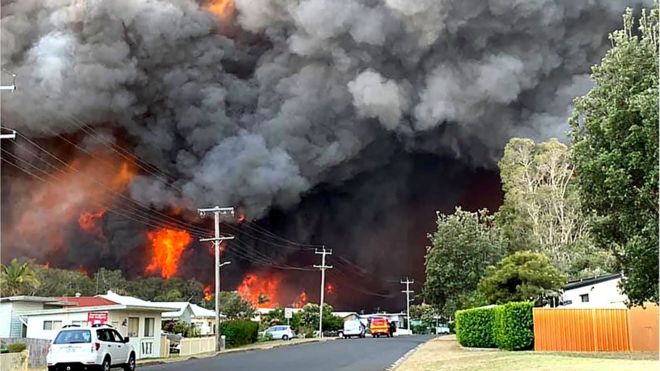
Australia Bushfires: State of Emergency Declared Over 'Catastrophic' Threat


Thousands of people have been driven from their homes - AFP

Two Australian states have declared a state of emergency as bushfires bring a "catastrophic" threat to heavily populated areas of the nation's east.

bbc.com - 11 November 2019

At least three people are dead and thousands have been displaced by three days of dangerous weather conditions in New South Wales (NSW) and Queensland.

But officials say the worst danger will come on Tuesday for areas around Sydney, the nation's largest city.

More than 120 bushfires are burning across the two states.

(CLICK HERE - READ COMPLETE ARTICLE)

ALSO SEE RELATED INFORMATION WITHIN THE LINKS BELOW . . .

CLICK HERE - Wildfires Rage In Australian State: 'We've Simply Never Had This Number Of Fires'

Country / Region Tags: 
Problem, Solution, SitRep, or ?: 

Map - Global Forest Watch Fires

Map Link
https://fires.globalforestwatch.org/map/#activeLayers=viirsFires%2CactiveFires&activeBasemap=
topo&activeImagery=&planetCategory=PLANET-MONTHLY&planetPeriod=null&x=0.000000&y=40.000000&z=2

fires.globalforestwatch.org

Global Forest Watch Fires (GFW Fires) is an online platform for monitoring and responding to forest and land fires using near real-time information. GFW Fires can empower people to better combat harmful fires before they burn out of control and hold accountable those who may have burned forests illegally.

GFW Fires combines real-time satellite data from NASA’s Active Fires system, high resolution satellite imagery, detailed maps of land cover and concessions for key commodities such as palm oil and wood pulp, weather conditions and air quality data to track fire activity and related impacts in the South East Asia region. GFW Fires also offers on-the-fly analysis to show where fires occur, and help understand who might be responsible.

By working with national and local governments, NGOs, corporations, and individuals, GFW Fires is working to quicken fire response time, ramp up enforcement against illegal fires, help ensure those who are illegally burning are held accountable, and coordinate relationships between government agencies.

(CLICK HERE - READ COMPLETE ARTICLE)


Country / Region Tags: 
Problem, Solution, SitRep, or ?: 

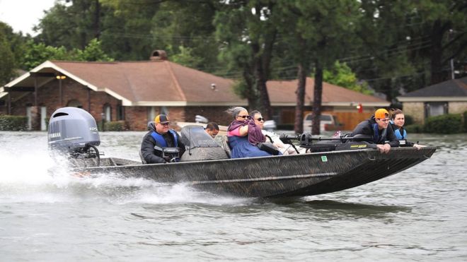
US Flood Risk 'Severely Underestimated'


During Hurricane Harvey, Port Arthur in Texas experienced some the most extreme impacts of flooding - Getty Images

Scientists and engineers have teamed up across the Atlantic to "redraw" the flood map of the US.

bbc.com - by Victoria Gill - 11 December 2017

Their work reveals 40 million Americans are at risk of having their homes flooded - more than three times as many people as federal flood maps show.

The UK-US team say they have filled in "vast amounts of missing information" in the way flood risk is currently measured in the country.

They presented the work at the 2017 American Geophysical Union meeting.

(CLICK HERE - READ COMPLETE ARTICLE)

CLICK HERE - 2017 American Geophysical Union meeting


Country / Region Tags: 
Problem, Solution, SitRep, or ?: 

NASA Map of Earth's Seasons Over 20 Years Highlights Climate Change

The visualization shows spring coming earlier and the Arctic ice caps receding over time

NASA - theguardian.com - AP - November 17, 2017

Nasa has captured 20 years of changing seasons in a striking new global map of planet Earth​.

The data visualization, released this week, shows Earth’s fluctuations as seen from space.

(READ COMPLETE ARTICLE)

CLICK HERE - NASA - The Living Planet - The Changing Colors of our Living Planet

CLICK HERE - NASA - Our Living Planet from Space

Country / Region Tags: 
Problem, Solution, SitRep, or ?: 

Facebook Disaster Maps - Using Data to Help Communities Recover and Rebuild

newsroom.fb.com - By Molly Jackman - June 7, 2017

Today, we are introducing disaster maps that use aggregated, de-identified Facebook data to help organizations address the critical gap in information they often face when responding to natural disasters. Many of these organizations worked with us to identify what data would be most helpful and how it could be put to action in the moments following a disaster.

This initiative is the product of close work with UNICEF, the International Federation of the Red Cross and Red Crescent Societies, the World Food Programme, and other organizations. 

(READ COMPLETE ARTICLE)

ALSO SEE RELATED ARTICLE HERE - Surveillance for good? Facebook tracks disaster victims

CLICK HERE - Mark Zuckerberg - Facebook

Country / Region Tags: 
Problem, Solution, SitRep, or ?: 

Map Shows How Paris Reversal Isolates U.S. From World


1Nicaragua refused to join the Paris Agreement because the country believes that the accord’s voluntary goals are insufficient.

2A brutal civil war and international sanctions made it difficult for Syria to attend the Paris negotiations and deliver an emissions-reduction goal.

Country / Region Tags: 
General Topic Tags: 
Problem, Solution, SitRep, or ?: 

How Likely Are You To Deal With A Zika Outbreak? Check This Map

huffingtonpost.com - August 15th 2016 - Anna Almendrala

Now that Zika virus is spreading locally in Florida, U.S. residents, and especially pregnant women, are growing alarmed at the risk that they may face in their own communities. 

A new map estimating the risk of local Zika spread around the globe shows a relatively small likelihood that most of North America and Northern Asia will be affected. By contrast, all the variables are in place for local spread in most of Africa, South and Southeast Asia. 

(VIEW COMPLETE ARTICLE)

Country / Region Tags: 
Problem, Solution, SitRep, or ?: 

Pages

howdy folks
Page loaded in 0.810 seconds.